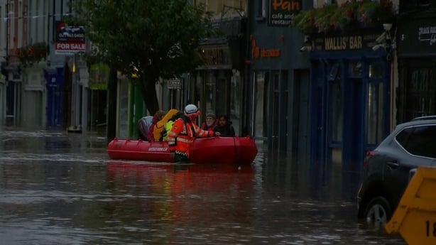
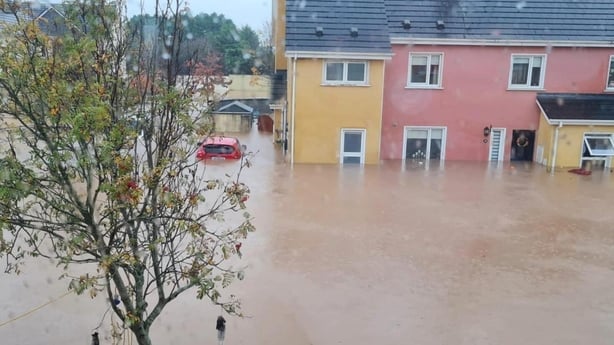
A new study has found that the extreme rainfall over two days last October which caused widespread flooding in Midleton and other parts of East Cork, was over twice as likely to happen at current global temperatures compared to pre-industrial times, due to climate change.
It also found that low tidal conditions at the time meant the town avoided a far worse disaster, despite it being the worst flood event on record in the area, damaging over 680 properties.
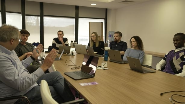
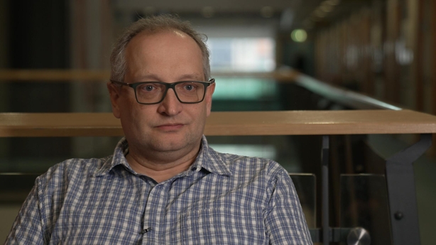
The study, a “climate attribution” analysis, is the first of its kind in Ireland and was carried out on behalf of RTÉ by Dr Ben Clarke, a scientist from the World Weather Attribution group at Imperial College London. He was working with researchers from the ICARUS Climate Research Centre at Maynooth University and Met Éireann.
It found when comparing the current climate conditions to those from pre-industrial times the chances of such heavy rainfall levels occurring today were 120% more likely.
It also found that the extreme rainfall over the two days on 17-18 October, had “an increased intensity of around 13% due to global warming.”
The Midleton case study used the methodologies of the World Weather Attribution (WWA) group based in Imperial College London. The WWA team is an international team of researchers from several institutions, including the Grantham Institute – Climate Change and the Environment, Imperial College London, The Royal Netherlands Meteorological Institute, the Laboratoire des Sciences du Climat et de l’Environnement, and the Red Cross Red Crescent Climate Centre).
Scientific techniques developed and tested over the past decade are used, so that in the aftermath of extreme weather events which cause damage to people and property, climate scientists can robustly answer the question: “what is the role of climate change in this event?”
According to WWA’s Ben Clarke, it answers this by determining “the changing probability of it occurring and when it does occur, the changing intensity of it” due to climate change.
“So, we come with an openminded view if climate is driving changes in risk and in this case, it is driving changes in risk,” according to Dr Clarke.
According to Met Éireann climatologist Dr Ciara Ryan for the first time in Ireland we can say that a specific weather event was made worse by climate change.
Until now meteorologists in Ireland have resisted the notion that you can blame any single weather event on climate change or say how it contributed to it. However, Dr Ryan says “with this study now we can.”
According to Dr Ryan, while for some time we have been able to say with confidence “that an extreme rainfall event is more likely to occur in a warming world, this study allows us to formalise that and to quantify it.”
In addition, the study also found the heaviest rainfall and “peak river flows coincided with low spring tide” last 18 October, meaning that the river “was able efficiently to drain into the sea.”
“Had the event occurred at high tide and significant storm surge, flooding could have been significantly more extensive” the study found.
One of the authors, Professor Peter Thorne, said it was “blind luck that we avoided a worse catastrophe in this case. The ocean was Midleton’s very best friend on the day.”
The study
Climate science tells us in general terms that more heavy rainfall occurs in a warming world. This is because warmer air holds more moisture and causes a proportionate amount of excess rainfall.
The team of experts looked at the specifics of what happened when Storm Babet hit Midleton.
“Storm Babet formed as a subtropical depression between Spain and Portugal and Canary Islands, and that was forming at the peak of the sea surface temperature annual cycle in a North Atlantic,” according to Professor Thorne.
“That was very, very warm – unusually warm. 2023 was record-breaking warm in the North Atlantic basin as a whole,” he said.
“And what happened was that when it slowly came up, it was carrying huge amounts of water vapour over a very large area. What goes up, fundamentally, must come down. As it reached cooler air, over the UK and Ireland, a huge amount of moisture came down and we saw flooding in Middleton.”
Professor Thorne says the finding that the rainfall was 13% “more intense” (i.e. in volume and speed) due to climate change is particularly significant.
“It could be the difference between the river being broadly contained within its banks or floodplain and what we saw in Midleton. Every percentage of additional rainfall is an additional risk.”
Flood is a response to the amount of rainfall that is going into the river catchment, so when an additional 13% rain falls across the whole area of the catchment, “it is a lot more flow coming through the river. So fundamentally it mattered,” Professor Thorne said.
There were certain factors, which contributed to the flooding, which the study could not confirm with certainty were driven by climate change.
So while the study found that the surrounding land was so saturated by rain in the three months of rain before the flood, that it couldn’t absorb any more rainwater, and so contributed to it, it couldn’t say that the high rainfall arose from climate change or “from internal climate system variability.”
‘Dodged a bullet’
Despite the damage and destruction affecting 682 properties when Storm Babet hit Midleton, the study found that the town “dodged a bullet” because the storm did not hit at high tide, nor was there a storm surge, (i.e. an increased seawater level due to storm).
“It actually hit a spring low tide with no surge at all. And what that means is that the ocean was basically welcoming the water coming down the catchment with open arms. It was acting, if you like, as a vacuum cleaner to Midleton, pulling water out,” according to Professor Peter Thorne.
Therefore businesses and properties at the top of Midleton were worst affected, where the river gauge showed a water level 2.5m above normal. While at the lower end of the town closest to the sea, where the tidal gauge was only 78cm above normal, properties were the least affected.
“We could have that same rainfall occur in future at a time when it’s a spring high tide and even worse when there’s a storm surge. Then you have water coming in from the south, you have water coming in from the north. And you would have far more catastrophic damage across Middleton in the future in such a scenario,” added Professor Thorne.
The future
It is these kind of insights from attribution studies that scientists say are important for future planning.
The hope of the authors’ is that they will prompt policy-makers to take the necessary precautions.
According to Professor Thorne “it is significant to understand, for any event, was it made more likely, more severe due to climate change?”
“Equally, was it made less likely, less severe due to climate change? If we’re going to make sensible decisions, if we’re really going to build a climate resilient island, we need to know the answers to these questions,” he added.
Dr Ben Clarke says there are now over 50 attribution studies worldwide allowing us to get a more accurate picture of how climate change is affecting weather events and where they strike.
“We’re building up an increasingly complex picture of where climate change is having effects on us and where it isn’t. That allows us to, in theory, prioritise ultimately limited resources on managing those risks,” Dr Clarke said.
Dr Ciara Ryan hopes the study can provide a template for similar studies.
“What we’ve done is build this framework that we can use to apply to future attribution studies when extreme weather events happen in Ireland, whether that’s flooding, heat waves or storms,” she said.
The study predicts greater risk of future adverse events – even greater likelihood of extreme rainfall and intensity. However, as we move to the global temperature of two degrees above pre-industrial norms the projected changes in frequency and intensity are harder to predict with scientific accuracy.
What we can say, according to Professor Thorne is “that in a two-degree warmer world, which is where we’re heading, if not beyond, the [rainfall] event will be made even more frequent and even more severe.”
He describes Storm Babet’s rainfall as “simply a foretaste of what is to come.”